Geographic Information Systems: Integrating GIS and AR for Immersive Experiences
Geospatial data is an important aspect of what drives people to explore and chart out new places. It usually comprises valuable pieces of information, such as satellite images, drawn-to-scale maps, and aerial pictures, among other things.
And it’s used to establish spatial relationships and patterns, once studied. In that same vein, geographic information systems refer to all the tools or hardware that are used in capturing, analyzing, and presenting geospatial data.
More importantly, it allows users to understand geographic information in new and improved ways, including the ability to visualize and then interpret the data.
On the flipside, we have AR which is a lot trendier in the digital world than what we know about geographic information systems. It’s an emerging tech that is popular in various fields such as entertainment, healthcare, education, and gaming.
Augmented reality works by placing virtual images on a person’s view of the real world – employing the use of smartphones, tablets, or interactive screens. If you’ve seen or played Pokémon Go, one of the top AR trends in recent times, or something similar, then you’ve experienced AR.
What are the Key GIS Components and their Uses?
GIS, as we learned above, refers to tools that help in better understanding geospatial data. Geographic information systems are used in combining various data sets, obtained from different sources, and then using it all to establish relations and patterns.
Here are some key components and GIS uses that are important for its application across various sectors:
✔️ Data Collection
Geographic information systems accrue data from different tools such as GPS devices, databases, surveys, and remote technologies (satellites or drones).
The data it collects is stored in an organized manner, with the different types being stored as layers. Here, each different one represents specific geographic elements including roads and rivers, or even parcels of land.
✔️ Analysis
Apart from collecting and storing the data, geographic information systems also use tools to analyze them for further use. Using analytical practices, they help users determine the trends seen within the data.
While clubbing information based on categories such as land use, population, natural resources, elevation, etc.
✔️ Visualization
GIS's capacity to build maps and visualizations that effectively explain complicated information is one of its primary capabilities. Maps may be adjusted to show certain layers, properties, and symbols, making it simpler to communicate information to a larger audience.
✔️ Mapping
Amongst the many cartographic products enabled by geographic information systems, one of the most important components are the high-quality maps that it provisions.
These can be basic reference maps that highlight borders and important geographical spots to thematic maps that help visualize specific phenomena, distribution of the flora and fauna, and more.
✔️ Integration with other technologies
Because it is not limited to one specific tool or piece of hardware for operating, geographic information systems can also adapt or integrate easily with other technologies. It has successfully done so with GPS devices and remote sensing technologies along with various software programs.
In summary, these are some of the key components of geographic information systems and their uses. One can see how GIS can predictably have a wide range of applications across a slew of different fields.
They are incredibly important in helping professionals from various industries research and gain insights: In order to better understand the world around them.
Of Convergence and Utility: GIS and AR Integration
Geographic information systems (GIS) and augmented reality (AR) are a pair of distinct technologies within their own rights. They have various use cases, spanning across different industries.
And yet, they are uniquely positioned to complement each other, if they are integrated properly by an augmented reality development company. Here are some use cases that can help visualize the convergence of GIS and augmented reality:
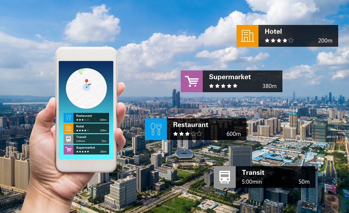
✔️ Navigation and Pathfinding
By deploying the data provided by geographic information systems strategically, AR applications can be programmed to help in navigation in a more visual manner.
The app or platform can use AR-assisted visuals to guide users through suppose, a city or venue for example. The same app can also throw up important pieces of information about the place, nearby sites that the user might find interesting, and other points of interest.
✔️ Collecting Data from Fields
Workers who are navigating the fields in industries such as mining, industrial farming, repair to outdoor machinery, etc. can use AR devices that project GIS data in their FoV.
By receiving data from geographic information systems directly into their field of vision, they will be better equipped to deal with their tasks. For instance, being able to see where underground pipes and cables go, site inspections, predictive maintenance, of old machinery, etc.
✔️ Emergency Response and Awareness
While responding to disasters, emergency teams can benefit from using AR displays that show real-time data from geographic information systems.
This can be beneficial for both rescue teams and on-site workers who can use augmented reality displays to view things like what route to take for evacuation. What zones to avoid owing to hazard risks, where the resources and supplies are located, and more.
✔️ Travel and Tours
Travel apps may mix Geographic Information Systems (GIS) data with Augmented Reality (AR) to provide travelers with useful tools and intriguing facts while they explore foreign cities.
This implies that when a visitor uses applications powered by AR/VR tourism, they can obtain navigational assistance and learn about the city's culture and history. All while acquiring insights into major monuments and points of interest. Related post: Virtual Travel and the Future of Tourism
This combination of GIS and AR can be set up to assist travelers in making the most of their trips – By giving them both practical support during their stay and also an enriching bank of knowledge about the locations they’d visit.
Take a look at some examples of companies that have already begun to integrate GIS and augmented reality:
Google: As an extension to Google Maps with which everyone’s quite familiar, Google also offers Live View which integrates AR-guided navigation onto a user’s device. It uses the smartphone’s camera to overlay wayfinding features, including maps and directions onto a person’s display – guiding them in an immersive manner without the usual 2D maps they’d see.
Matterport: By incorporating the use of 3D mapping technology and spatial intelligence, Matterport has successfully created AR experiences for real estate. Spanning various uses such as allowing buyers to view properties virtually, and realtors and homeowners to showcase their work and holdings, all while presenting the full details on digital displays.
Ubisense: With their proprietary ‘SmartSpace,’ Ubisense is able to offer industries AR solutions that combine GIS data for various tasks. Including asset management, maintenance, manufacture, and more.
Combining GIS and Augmented Reality for Spatial Understanding
In this manner, by increasing one’s understanding of spatial information from GIS tools, AR can well integrate with geographic information systems. And give us new, immersive ways to help with decision-making. Going forward, you can be assured of experiences that are contextually relevant and informative.
At EDIIIE, our team can help you explore the possibilities that stem from incorporating augmented reality for businesses. Whether it’s to enhance navigation for your users, provide insights, display data in real-time, or more – merging GIS with AR can help you navigate new endeavors with our team.
Contact us to discover how you can interact with spatial data in innovative ways. Learn how we can shape the future of your digital experiences, starting today.